I haven’t been able to finish writing up my holiday in Austria as I contracted Covid on the way home and I am quite poorly. I tested positive on Saturday night. Once I am feeling better and have caught up on work I will complete the holiday blog. I won’t be walking for the next few weeks either.
I remained covid free for 3.5 yrs and I was bound to get it sometime, so can’t complain. See you all once I am through it.
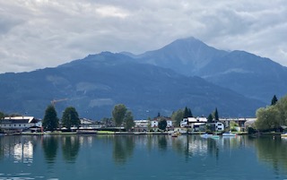
The day had a promising start, with sunshine, after a dramatic storm overnight with thunder and lightning that almost burst a few eardrums. We set off from Sankt Johann (nicely pronounced by the operator at the railway station) for our 45 mins journey to Zell am See. This is a most attractive high level ride for much of its route, meaning you have excellent views of the mountains and valleys. It moves quietly through one valley to another. There is no indication of a lake until you reach it – it comes as something of a delightful surprise. Indeed, if you travel by road, you can avoid seeing it at all!
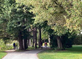
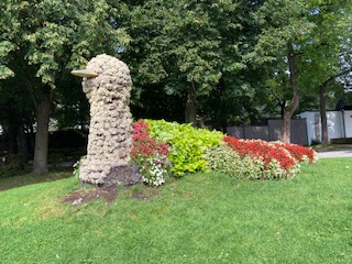
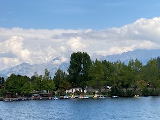
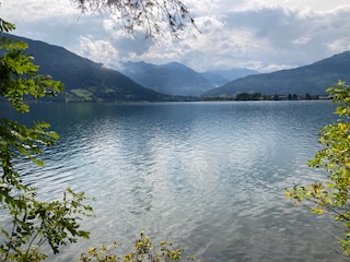
Zell am See has a calm and warming peacefulness. It is as if the surrounding mountains engulf and protect you. The lake is not huge, just 4 km long and 1 km wide, and 68 metres deep. It is a healthy place and the lake water good enough to drink, if you dare to try it. There is a footpath and a separate cycle path around the lake and plenty of places to stop for refreshments or to simply enjoy the magnificent views. At various points in the path are areas sheltered with trees and other places for children to play, all kinds of sculptures dotted around and water sports in abundance.
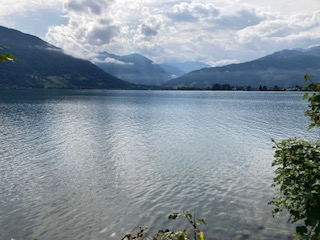
We did our own version of a watersport by taking a ride on the boat. This was enjoyable but at the same time unnecessary as you can see everything you want to see from beside the lake. However, the skyline was telling its own story. To the north, with its slightly lower mountains the sky was blue with puffy white clouds. To the south the clouds were grey and gathering and had a sense of foreboding; rain was clearly not too far away. For now though, it was bright if not hot sun, and warm enough to entice one into a lager.
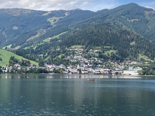
It was then time to explore the town itself, which is fairly small but even so has over 10,000 inhabitants. It also has an ancient history, as far back as the Bronze Age, and it was a trading post in more recent centuries. Learning about its past will have to wait until I have a chance to revisit this area. There are cable cars up to its central mountain, the Schmittenhohe, itself standing impressively at 1965 metres. From here, you are able to see over 30, yes 30 mountains over 3000 metres high, including the Grossglockner that we visited a couple of days ago.
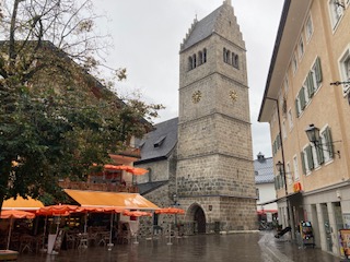
It was at this point that the heavens opened, and they weren’t even kind enough to give us much warning. I went in a shop in the dry and came out to a torrent of water flowing down the street – well, maybe not a torrent but you get my drift. They are clearly used to frequent downpours as the cobbled streets all have drainage channels that work very effectively, which is more than can be said for some inconsiderate drivers who soaked me as they sped past! Time for some shopping – I had needed to buy some new trainers and this was the perfect opportunity, and I found the best shoe shop I have been in for many a year. The lady actually wanted to help me, had some really good knowledge and as a result I am now the owner of a new pair of goretex shoes. She insisted I wear them straight away given the inclement weather, so my shoes and I went to look at the church in the main square, with its 15th century tower. As you look down the side of the church, it feels as if this is the only remnant of a bygone age, being surrounded by more modern buildings, but I suspect there are various gems to be discovered hidden away in the town.
It was then time to make my way to the Bahnhof for the return journey. The waiting room had one last surprise for us – exceedingly comfortable and colourful seating. Well done to the designer – compare this with the uncomfortable slanting metal seats we have in the UK and islands bus stops. Once on the train, I really wanted to see where the lake must spill into the surrounding plains but I didn’t detect any outlet. I have since learnt that the lake used to be much larger, reaching as far as Salzach, and much of the northern end has been drained, although there are still swamp areas in places.
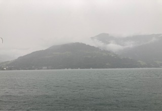
By now the rains were eradicating any fine views of the mountains, but no matter. It is good to see landscapes in all their various moods and colours. Tomorrow, we visit Salzburg and we will have a guided walking tour, and this probably whet the appetite for future visits as I am sure we will not be able to see all we want to see in half a day.
This turned out to be the longest and hardest walk I have done in years. I was expecting it to be 10 miles and about 1600ft of ascent but in reality both were exceeded.
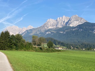
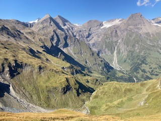
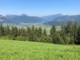
I started out at 8.30am with the intention of finishing the walk between 2-3pm and then taking the Gondola up one or other mountain. It was a warm day and the sun glistened on the river as I walked beside it up to Rettenbach. This lies in a plateau and the surrounding mountains stick out as a fine backdrop every way you turn. The only thing to spoil it at all was the sound of the traffic on the main road.
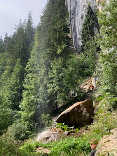
I reached Rettenbach easily and started looking for the footpaths that would lead uphill. In so doing, I passed a woodturner’s premises with the aptly named business title of Holtzwurm. Outside his premises he displayed some of his wares and fine specimens they were too as you can see in the photo below. Just past his domain was the first waysign to the Schleier Falls and I followed this path a short distance until it turned into a different sign saying Wanderweg, which usually means a contouring path circling an area. Look as I might for the path I wanted and I thought I had found it until this petered out. I made the classic error of not turning back immediately and got myself into real hot water when there was no clear path forward or back, just loads of vegetation and trees. Oops! I managed not to panic, and decided that if I keep the ravine to my right and the sun just to my left, I should ultimately return approximately to where I had started. These navigation skills supported me well, along with some odd black and white posts that I thought must lead somewhere, and after about 40 mins of traipsing aimlessly in the forest I found the original track, and just kept going, even if I was reasonably sure it was not the path I had originally wanted. Phew! I could breathe again.
I eventually I came to a path that did suggest it was going in the right direction and I followed this very successfully, passing lumberjacks clearing some of the forest and an old man resting on a log.
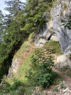
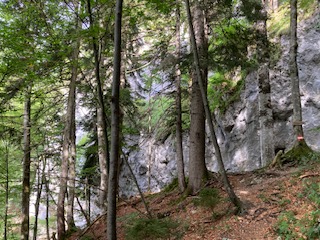
There are many twists and turns and false tracks to avoid on this walk. I did have a landscape map of the footpaths in the area but it wasn’t accurate. Some paths are unmarked on the ground, other paths are named but do not appear on the map, so whether you find your route successfully is rather hit and miss for the tourist. It is all heavily wooded, with no views as you make your way uphill. That is not to say it is unattractive, but it is unrelenting. There are also sections with steep drops and narrow paths, so not for the faint hearted.
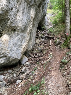
By luck rather than judgement I seemed to find myself on the track I had intended, but what I didn’t know was where it would lead. There is an area called Debils Ofen, which I assume means Devil’s Oven, which is a series of caverns at the base of a massive rockface. The footpath actually passes through these, so I imagine when deluges come in winter this route will be entirely cut off. There were tree trunks and branches strewn along its course, evidence of previous activity.
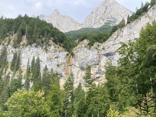
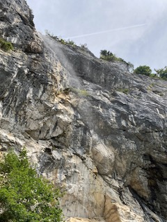
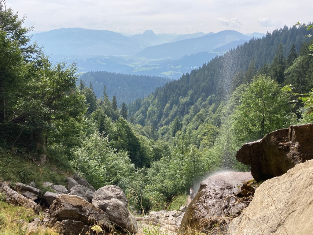
Beyond this, the path makes its way annoying downhill, when you know that you have to go uphill, and sure enough just when you can hear the rush of water indicating you are getting near the falls, the path diverts uphill. There is a small summit and you can feel open space beyond, and I could hear voices chattering and laughing, so my sense of excitement grew. Be careful though not to get too excited as the path down to the base of the falls is rocky, with some large, and some small stones. Once your eyes adjust you can see the water cascading over the overhanging edge, looking rather like a shower curtain. There are other smaller falls, which no doubt become raging bulls in winter. I stopped temporarily under once such fall and washed my fevered brow. It was another very hot day, and for once I had felt the effects of the high altitude, so I took care to take my time, monitor my breathing and get back on an even keel before continuing.
It is much more interesting than it appears here in the photos and it is a very restful place.
The path down is a great deal easier than the path up, mostly on a fairly wide track. At the start, it is clear that my way down was most people’s way up as the stones were shiny and it would be easy to slip. Again, there are few views on the way down. The never ending tree lines are relieved in places by the children’s activity areas, which have been very cleverly designed.
Once back on level ground I decided to take the easiest road route back to St Johann. Having already done 11 miles, I didn’t want any false turns now and wanted to get back.
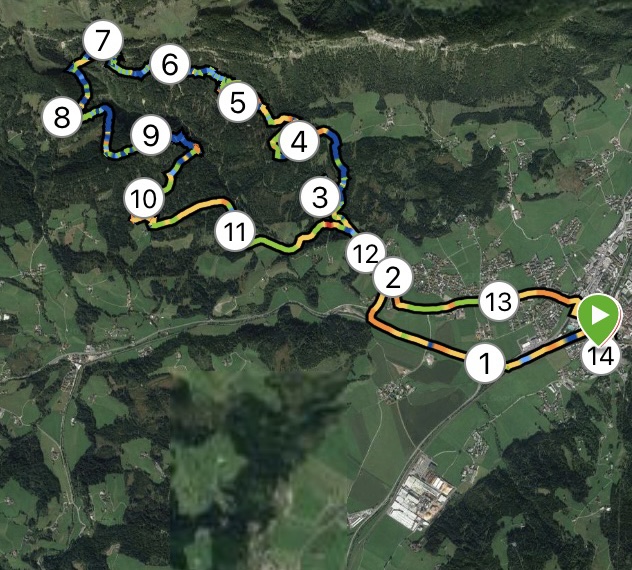
My Garmin watch recorded my route, which bears no resemblance at all to the paths on the tourist map I was given. I would recommend buying the Austrian equivalent of one of our OS maps or visiting the tourist information to get an up to date map and guide for any walk you intend to do. And make allowances for the high altitude, as it is relentlessly uphill for 7 miles.
Distance: 14 miles; Ascent 1988 ft; Descent 1949ft; Minimum Elevation 2224 ft; Maximum Elevation 3817 ft.
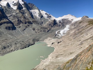
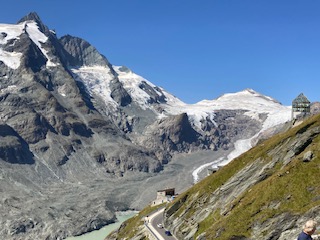
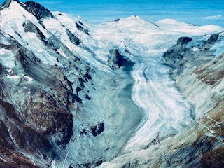
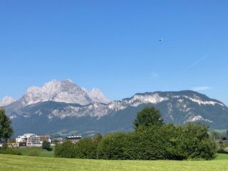
This was not a walking day, but an exceptional day for views as the coach took us higher and higher to the very apex of Austria – the Grossglockner. The images speak for themselves, and although I could name ridges and mountains I doubt if you would care much. The glaciers have retreated enormously since I was last there in the 1960s. I remember having a snowball fight with my peers in this location, but there was not a drop of snow to be seen below the glacier level this year. There are numerous notice boards dotted around the visitor sites, explaining that the process of deglaciation is not uncommon in the vicinity if you look back over the aeons. Nonetheless the rate of change is quite remarkable as you will see from the photos.
and from former days:
After this, we travelled to the beautiful alpine village of Heilingenblut. This traditional village has an iconic church and tremendous views down the valley, but little else for the passing tourist unless you have time in your hands, in which case you could visit the waterfalls or amble along the valley. The church graveyard was beautifully maintained with flowers in every single grave and with photos of the departed in each one, enjoying the afterlife as in life, with the glacier in the background.
On this journey, I found it quite remarkable that where the glaciers would have combined to be a great force to be reckoned with, where the dams now exist across their exit down the mountain, there is only the merest sliver of land through which all the water would have had to travel when the snow melted. I imagine this must have caused catastrophic floods during its ancient history.
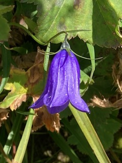
There were also some lovely alpine flowers including masses of purple gentian and a hapless butterfly feeding on a plant yet to be named.
Tomorrow I am planning a walk on my own again, after a trip up the Gondola to the top of the local mountain.
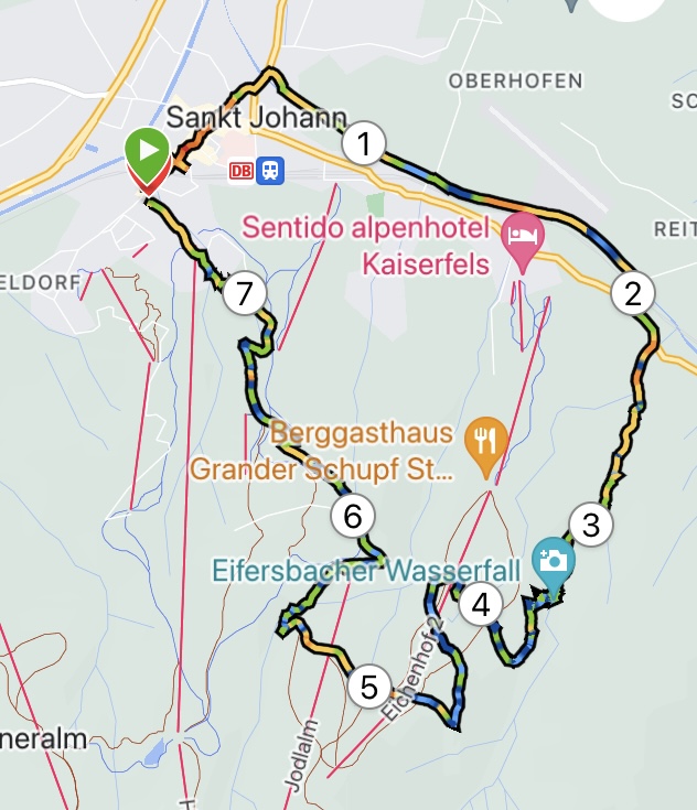
You were right. Even though this is a Great Rail holiday I would have to do my own walks. A holiday is not a holiday without stretching the legs, for me at least. To be fair, today was the ‘off’ day. Looking at a map I noticed that the Eifersbachers Falls were within walking distance of the hotel in St. Johann.
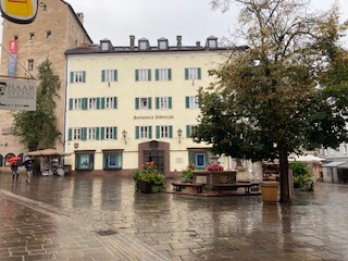
The walk begins with a stroll through the very attractive town of St Johann. I need time to explore this when everything is open, as today was Sunday. Crossing the bridge, the path runs alongside the river for about a mile or so. It is very open here, so you get the full effect of the sun. Just as you pass the airport, well not so much an airport as an aerodrome for small aircraft, you cross back over the bridge to join the main road. Don’t take the side road as this will take you down a blind alley.
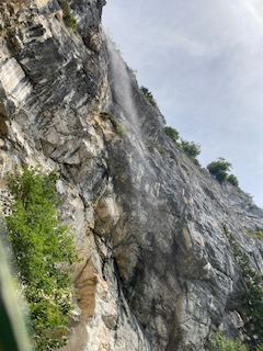
Follow the road to the left for about 200 hundred metres, then the path is shown on the yellow waysign to the right. This is a delightful path, leading through the forest, with not too strenuous a gradient, until you reach The Eifersbacher Falls. These are tremendous with two or three separate falls, even at this time of year when there has been little rain. There is clearly a separate waterfall in winter too, but this was dried up now. You do need to be prepared for a very steep uphill section of about 300-400ft, way above the top of the waterfall. There is no alternative route unless you retrace your steps. However, the climb is worth it. Once at the top of this path, take a left, again traversing uphill, until you reach the Hornblicksee. This is a lovely lake, with loads of places to sit to enjoy the view all the way down the valley and into the surrounding hills.
There is a choice of paths from here. Very high, high or low. I took the high path that goes across the meadows underneath the cable car and ski runs down to a pension called Pointenhof. The views from here are ‘disappointing’ compared with previous views, but the beer was very welcome. Ironically, the hotel had arranged breakfast for us here earlier in the day, and that too was disappointing.
There aren’t many routes down to St Johann from here. I followed the main road downhill most of the way, as the one place I had thought of a change of direction was not marked as a footpath off the road. Instead, a few bends before you reach the cable car station is the most delightful walk through a wood that comes up right next to the cable car station. It has play things for children, and plenty of attractive seating area, so worth a visit on its own. From here, it was just a short walk back to the Hotel Park, and a nice shower after the very hot day.
Distance: 7.5 miles; Ascent 1650ft ; descent 1365 ft. Minimum elevation 2,234 ft; Maximum elevation 3598 ft.