Day 2 Mallorca – Sóller round

Today’s walk was 9 miles and 1388 ft of ascent, slightly more than in the advertised programme, but the extra 88ft perhaps mainly accounted for by my scrambling about on the limestone rocks whilst the others had their lunch.

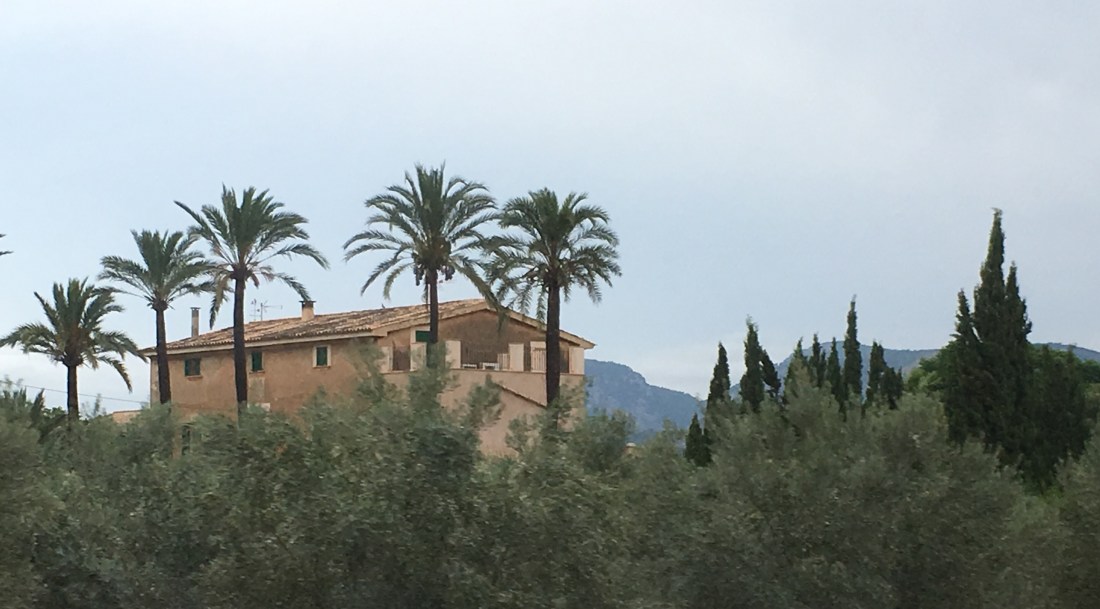
This was a circular walk from Port De Sóller, commencing with a half mile walk along the front before turning off onto a B road and then onto footpath number 221. The paths are clearly marked and wide by our standards, and very well maintained. They mainly comprise either cobbles or limestone interspersed with clay soils, so a little uneven. In rainy conditions these could be treacherous but today it was a fine day with only a spattering of rain every now and again. The path eased us into a gentle ascent providing views towards Sóller. However, it was a persistent ascent for some distance and not being a morning person I would have preferred to have taken this at a slower rate, given that we had a full day for this walk and it was very hot and humid. However, another of our party was equally irritated that we weren’t going faster as he was, as he told me, ‘out for a walk’, as opposed to a walk and a chat which is more common with group walks. Who would be a group leader, trying to keep everyone happy? I sidled along at the back most of the time taking photos and admiring the views. I think we were on the path called Torrent de Son Sales unless that is the name of the stream! We were walking around the Serres de Muleta group of hills. Postscript: torrent does mean river, though as you will see on my other posts, the whole of the island rivers seem to be devoid of water right now.

We stopped for elevenses at a cafe/restaurant, that was both scenic and interesting in that it had old machinery, and seating areas on different levels, but as I didn’t want to buy drinks but eat and drink what I had bought with me, I wandered off and found a rock to hide under to eat my pastry. This was the high point between the Sóller valley and the valley to the west with sea views.

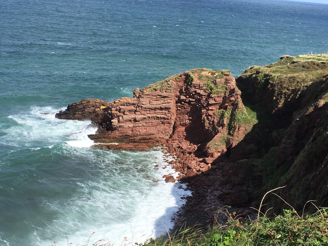
When we resumed our walk, it was only for a short distance to take us to a superb vantage point near the coast, and for me this was the highlight of the day at it involved messing about climbing and scrambling over limestone rocks. The others stopped and had their lunch so I could take my time looking at the different types of lichen and being curious about the weathering of the rocks, which are different from the limestone rocks at home. The limestone here is far more jagged and would cut you to pieces if you fell on it. It has little shards of glass-like rock sticking out in places. I found several fossils too. On the map, this is about at the 5 mile marker.

After that we retraced some of our steps to rejoin the inland path, where we were to meet our guide. The olive groves are ancient, gnarled and twisted into different shapes. They have a sculptured look as if some farmer had taken a lifetime pride in developing their contorted shapes. They looked if they could tell a story or two. Some of the olive trees are well over five hundred years old, although it is the 5-10 year old trees that provide the best olive oil.

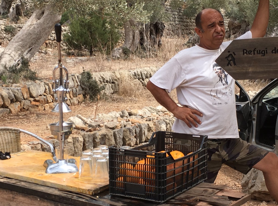
We met our guide at a junction in the path where a local was selling freshly pressed orange juice. He doesn’t look very happy in my photo though he was doing a nice steady trade. A glass contains 3 large oranges for 3 Euros, and it was worth it. It was delicious and gave me a burst of energy that lasted all the way back.

07814a8d-3a2b-431c-8b80-17a7a5b024ea.jpeg

Our guide told us about how the countryside is protected from the elements, including rock falls, by creating terraces made of limestone walls all the way down the mountain. It also enables them to guide the water in a controlled way as in winter there is more than ample rainfall toppling down these hillsides which would dislodge the soil and create mini landslides. We came across a lime pit – it is a lime kiln, but that would conjure a different image. This is a dug out section of land which is filled with layers of limestone and vegetation and topped with pine, the fuel to burn the lime.  It is repeatedly heated and churned over to produce lime that can be used not only on the fields but also for white washing houses. It acts both as a firebreak and a disinfectant and therefore is often painted onto Mallorca kitchen walls.

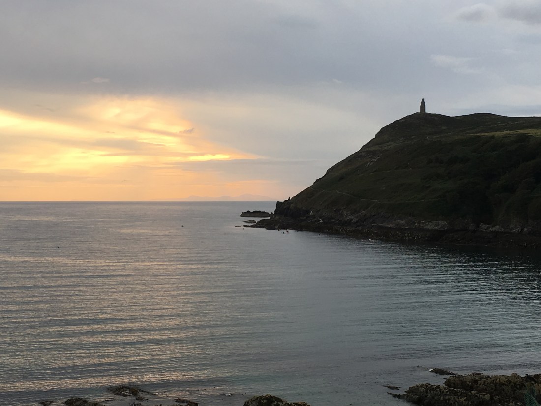
A short climb took us to the Refugi de Muleta. According to the Collins English Dictionary, the word ‘muleta’ refers to  the small cape attached to a stick used by the matador during the final stages of a bullfight, so quite why it is called this I don’t know, except this could refer to the shape of the rocks on the top of the hill perhaps.  Beside the hostelry is a lighthouse here called Cap Gros. From here we descended most boringly all the way back to the hotel for almost 2 miles entirely on road. I say ‘we’ but at this point another guest and I independently left the party to walk at our own pace, and I didn’t see him or the party again for the rest of the walk, though I understand they stopped and very sensibly partook of the local beverages on the way home. The views of the bay as you curve round are wonderful, but its one of those walks that once you have done it you probably wouldn’t bother again because of the amount of road walking.

Tomorrow’s walk will be a challenge for me as it is 8-9 miles and over 2000ft ascent, never mind the descent. So, the most challenging walk since I recovered from my chronic illness.


Arrival in Mallorca Sat 8 September- not the Isle of Man.

My first glimpse of Mallorca was from the plane as we skirted over the hills from the north to south of the island. The craggy beige hills were speckled with green shrub and trees dropping steeply into the sea and seemed to go on for ever. This looked promising.

Landing at Palma was less exciting. The view here was of an extended low level plateau to which the city of Palma owed its living. Our host, Trevor, told us about the hundreds of water wheels that adorn the plateau, mainly drawing water. The adored hills and mountains rose from its edges rather like a pastry crust. There aren’t high rise flats in Palma as we are used to seeing, but many apartments of 7 or 8 floors, with the same balconies, awnings and shutters, all very consistent and synchronised with their environment. As we edged out of Palma there were more hamlets with bungalow style houses and many had small enclosures for sheep, goats and hens. The scrubland gave way to lemon trees, olive groves and walnut trees.  As I was on a bus, and on the wrong side of the road, it was impossible to take many useful photos.

We travelled through Sóller after barely 30 minutes and soon arrived at our hotel at Port De Sóller. We passed many an island in the road and each one had some kind of statue or stone ornament, until I wanted to take a photo for you and then there were just trees on the islands.


A port it may be, but I am yet to see the ‘sea’ as by the time we arrived it was late. The Sóller Beach hotel is very lovely, and the food out of this world – I was in my 7th heaven, eating my perfect kind of food and not having to cook it for myself! However, I was expecting to see sea for miles around, but that isn’t the case.

After dinner, I took a stroll and visited the local supermarket. It is a very relaxing village with a lot and I mean a lot of boats, of all sizes. The hills rise from the lagoon shaped harbour and with the evening lights and entertainment what’s not to like. A local musician was strumming away by the quayside and the local drinkers and eaters were suitably appreciative of his laidback style of music.

CDD55CA7-6B03-4726-8C60-CB81A0FC850E

75230A68-44CB-4816-9200-8DFA341D38E7

So tomorrow, there will be daylight and our first walk of 8 miles and 1300ft of ascent. And for once I won’t do it in 3-4 hours as I would on the Isle of Man and shall enjoy a leisurely day soaking up the delights of Mallorca.

Figure of 8, Cronk Ny Arrey Laa, Tuesday 4 Sept 2018, 8.78 miles, 1533 ft of ascent

This is a walk of endless possibilities and permutations. Well maybe not endless, but there is a wide variety of starting and finishing points. If you prefer to finish with a downhill section, then start at the Sloc, as virutally any other path will mean a long uphill section at the end.

I started where the road turns to the right and a farm track continues to Dalby close to the top of Cronk ny Arrey Laa ( a regular parking spot for walkers), then descended south along the permissive path to the Sloc. It was interesting to see that the heather and gorse on the eastern side had virtually finished, whereas it was still in full bloom on the south side. On the eastern side, several shallow drainage ditches have been dug, and even though we haven’t had a lot of rain, every one on the eastern side was working well, with water in them flowing off the hillside.

When I reached the Sloc, I decided to blaze a trail to the top of Cronk Ny Arrey Laa, taking in the hillocks on the cliff line – cliffocks? – which are avoided by taking the standard path.  Clearly others have done the same from the footprints and loosely made  paths that I followed from time to time, but this was entirely new to me. It was quite thrilling and provided me with views that are usually unattainable. I did see one gentleman on the traditional path looking quizzically up at me. I couldn’t decide whether he thought I was just bonkers or whether he quite fancied traipsing through the heather himself. For me, it was worth the extra ascent and descent, but as he didn’t join me he obviously thought I was bonkers.


On reaching the highest point of the day, Cronk My Arrey Laa (437m), I descended via the steep coastal footpath which, once off the stony Manx group, crosses the wide and boggy moors towards Eary Cushlin and Dalby Mountain.

IMG_5639

IMG_1554

Here I was meeting the Manx Wildlife Trust again, this time to assist with the project “Bouncing Bogs”. I say “assist” but I am really not a lot of use, but I am learning a lot, and in time I may be of some use! I was late because I had got the time wrong, but it was neither here not there, as is usually the case with Manx time-keeping, and they hadn’t started. Dawn showed us bog asphodel in its orange burst of autumn glory, bog cotton, sheep’s bit scabious, eyebright, tormentil, purple knapweed to name but a few. She showed the children how to strip the soft rush to create rush lights and plucked and flicked thelicopter seeds from the nearby sycamore trees providing amusement for the children, though it has to be said the most fun was had by jumping about in the bogs. The gooiest thing of the day was a very ugly and slimy slug, which rather delighted Dawn. One thing we sadly didn’t see was the sundew which is common here, but maybe a little late in the year to show itself off. I havent included this section in my walk stats as this was an extra.

I then proceeded along the Bayr ny Skeddan towards Glen Maye, another route I had never walked before. It was just lovely, with continuous changing views across to South Barrule. The path is easy and flat until the end when it descends steeply to the river Rushen. This path is accessible from Eary Cushlin /Dalby Mountain car parks and is worth a walk on its own. You can see the mines, the river valley,  and the moutains  from a unique angle. Unfortunately, at this point, I ran out of battery – again – but I will revisit this area another time I am sure and take more photos.


I stopped for ‘lunch’ when I crossed the river Rushen. There are a couple of good places to have a picnic lunch here, either at the bridge sitting on the stones, or if raining, just a little further upstream there is a gate leading to a grassy and tree-d area where there is a confluence of streams. I sat by the bridge for a while. The sun was beaming down and the water trickling over the rocks, and I didn’t want to move.

From here, I ascended using the farm track to Round Table. It is reasonably steep initially and then becomes a softer climb, but it is all up hill. From Round Table, I continued across the moorland which does seem to go on forever, although it is no more than a mile or so. You can see the cars parked at Cronk Ny Arrey Laa from Round Table and they look deceptively close. This path was quite boggy and slippery and of course, still uphill.

IMG_1030

I can throughly recommend this walk; you maybe don’t want to do it all. If you did the first half of the figure of 8 to Eary Cushlin you could join the Dalby track back to the car and this would be no more than 5 miles. Or, you could start by walking down the Dalby track and just do the second part of the figure of 8, and that would be about 5 miles too.

So that’s my long walk for this week. I am off on my hols to Majorca in a few days and work has to take precedence now until I go. I shall have my Garmin watch with me on my walks in Majorca so I may do a Majorca blog while I am away if I have an internet connection.

A walk on the wild side – Saturday 1st September 8.6 miles, 583 ft elevation

I was awoken by the sound of cows mooing this morning – which is a little strange given that I live on a housing estate. Little was I to know that cows would feature prominently in my activities today. Or maybe I was hallucinating having had so little sleep thanks to Homestay guest, who after a night of liquid indulgence and jollities had thought fit to walk some complete strangers home up to Bradda and then take a rest on the way back to listen to the waves crashing on the beach from a wall at Spaldrick. He was so relaxed, recumbent on his hammock wall, that he fell peacefully asleep there until the early hours, unknowingly perched precariously next to the significant drop leading down to the beach. My text message at 1.37am appears to have woken him up, so he drowsily got himself together and staggered back to his lodgings where he indulged in a couple of slices of toast and jam at 2am and regaled me with his stories until 3am.

So, the morning started slowly as neither of us had any get up and go, though go he eventually did to Jurby. I had planned out a short walk for myself. It was a dull damp day with nothing to commend it, so I opted for a low level country route. It started promisingly with an unexpected trip on the steam train to Ballabeg. This did add on an extra 1/2 mile but that didn’t bother me as I was only doing a short walk, but you could get the bus to Ballabeg and get off at the corner.

IMG_3764

Walking up the road out of Ballabeg I had spotted what looked like a tiny circular road on the map which looked interesting and it would get me off the ‘main road’. I followed this track for about half a mile before it then gave up the ghost and did not continue on where it was shown on the map. Being the explorer that I am, I thought if I hop over this fence and walk to the edge of the field then I should be able to join another footpath. It was quite misty so no-one would see me, except the minute I got in the field a herd of cows came over to say ‘hello’. Having convinced them that I was not of any interest to them they trotted off  into the mist. I was now in a large field and unable to see a thing, so I got my compass out to at least make sure I was going in the right direction. When I got to the edge of the field there was no exit and the many cows reappeared and were keen to enquire as to what my business was in their field. It was daunting having 15 or so cows staring eyeball to eyeball with me and I did not feel inclined to test their humour by taking any photos of them. It was a case of who could stare the other out for longest. Eventually they got bored and went off, so I made a fairly hasty retreat as soon as I knew I was incognito in the mist. I climbed back over the fence and retraced my steps all the way back to the road. Interestingly, the Garmin map showing my route does not show the path that is on the 1:25000 so the latters appears to be out of date.

It was now raining quite hard and I followed the road until I met the footpath/track I had been trying to locate earlier. This is not an interesting path, but I did see my cows again, this time from the safety of being the other side of the hedge. In fact, this is a very boring path, but it does have its moment. At a farmyard, there were dozens of squawking ducks and geese which came as quite a surprise.

IMG_5396

The footpath here was shown to deviate from the main track at this point, but it looked so overgrown that I thought it wasn’t going to be possible to continue. But the map showed the footbridge and this being the way,  I tried again and ignored the wild boar in the enclosure. I found a very very rickety stile completely overgrown leading into the ancient woodland. How ancient it is I don’t know, but it wasn’t one full of conifers.  This became my lunch stop out of the rain. Coming out of the boggy woodland I was surprised and delighted by the river winding its way through the enchanted trees. I could imagine this being a place for story-telling and fairies.


Crossing the bridge led to another fence /stile to climb over that was even more unstable than the last one  – the gate didn’t open and the wooden structure swayed as I stood on it. I was now on the track up to the Grenaby / Ballabeg road. I turned right and walked a short distance to the marked footpath on the left that would take me to Billown. This was waymarked but not easy walking as the turf had been dug up by the cows’ hooves, and yes, you guessed it, some more cows thought I was the most interesting thing they had seen today and started to move rapidly towards me. This time, though, I was one step ahead of them and stood on top of the stile to take their mugshots.

IMG_7670

I couldn’t find the exit path from this field, that thankfully had no wildlife in it, so I opened a gate rather than climbed over it (there’s a novelty) and another, and walked through Upper Billown farm.  I followed the track, but being tired and dim from the last evening’s festivities I took a wrong path. It didn’t take me long to discover my error and I was soon back on track and eventually joined the Ballmodha Straight for a very short distance before turning left by the milestone onto the track that would take me to Ballasalla. And of course, a dog had to come out to greet me very noisily at a farm, and more cows followed my every step before my day was done.

IMG_9302

Not a great walk; not one I shall do again in a hurry, but it did have its moments, especially the enchanted forest where the Silverburn really begins its epic venture to the sea. If you were to do it in a straight line, without unnecessary detours, it would probably be about 7 miles altogether.

Tomorrow, I am on duty at the Scarlett Visitor Centre so no danger of any intimidating cows there!

IMG_5357

Not the usual kind of walk….

I am not planning to do a walk today, though you never know. For the last 50 days, I have exceeded 5 miles every single day and my weekly intensity minutes too, so I think I am entitled to a day off! And just to make you tired I have walked 418,944 steps this month, which is the equivalent of over 200 miles – almost 1/3 of the Southwest Coast Path, which I did with one of my sons over 20 years ago.  I digress. So if not walking, I thought I would share with you some of the more unusual things I have seen or done this week on my walks.

On Saturday, I was treated to a superb display of fish aeronautics as a shoal of mackerel were hunting baby crabs around Port Erin beach for several hours – at least that is the latest story I have heard. It was similar to what I imagine the Northern Lights might look like, the fish changing direction and formations to make the most of their catch. The gulls stood waiting for their moment to pounce. It was all quite mesmerising.


And yesterday, I did a walk from Castletown to Silverdale Glen (and back) to assist in  “Splashing about in Silverdale”, an event run by Manx Wildlife Trust – http://www.manxwt.org.uk/ –  to introduce children to the secret delights of underwater river life. The river is thankfully unpolluted which enabled us to find a wide variety of creatures. Having been instructed on how to use the nets effectively and our feet to disturb the wildlife, we soon found mayfly nymphs and stonefly nymphs, fresh water shrimps, worms, caddis fly cases to name but a few things. Dawn Dickens was her usual brilliant, enthusiastic self making it fun for children and adults alike. She showed the children how the caddis fly builds a nest with tiny stones that stick to the rocks, so we all spent a happy few minutes turning the boulders over in the hope of finding the spoils, and we were not disappointed.

Next Tuesday is “Bouncing Bogs” at Dalby Mountain – we hope to see you there, too.

On the way there and back, I couldn’t resist collecting blackberries from the hedgerows, so part of today will be spent making blackberry and apple pies to freeze.

IMG_5315

But first of all, work beckons…


Slideshow of Milner Tower and Bradda Head, 4 miles Wednesday 29th August 2018

A stunning evening walk around Bradda Head, just 4 miles or so from my house. Do you need any other reason to live here?

There is quite climb up to Milner Tower which might not suit everyone, but there are other options to reach the top. If you take the car to West Bradda you can take a gentle sloping path with barely any ascent all the way!

Check out this video I took last night – I can’t upload it here, so have a look on my Facebook page:

Castletown to Langness Golf Links (No 19) and Fort Island – 4 miles (return 2.5 miles), Tuesday August 28, 2018

This short walk may be mostly on road and only a relatively short distance, but it is nonetheless spectacular in its simplicity, its peacefulness and breathtaking distant views in all directions, not forgetting the sea breeze that might sweep away any lingering cobweb at any moment. The bonus is the start and end point at Castletown, with its fine buildings, windy streets, castle and teahouses.

I was meeting some friends who had had an apartment in the Brambles at Port Erin when I was living there. They had moved to Anglesey and they were unexpectedly visiting the island for the Grand Prix, so we arranged to meet at No.19 for lunch.

For me, this meant I could get the bus to Castletown and then walk along the various beaches and shore lines with their different ambiences and if time walk the perimeter of the Langness peninsular. Today, this was unlikely as I had to get back to teach dancing but one can but dream…

I had thought of visiting the Castle first but decided I wanted to visit Fort Island and there wasn’t time for both, so I grabbed a takeaway coffee and walked round some of the quaint streets that comprise Castletown before visiting the loos on the bridge (worth knowing where they are, as there aren’t many that are open every day in Castletown). The loos in the Town Hall are closed at weekends.  I walked down past the Peggy Museum onto the coast road. I sat on some steps overlooking the bay and watched the tide whilst I drank my coffee, then resumed my journey stopping briefly at Hango Hill opposite the King William’s College and continuing on to Derbyhaven.


Photos: Derbyhaven Bay, Hango Hill and King William College

Here, rather than taking the road I continued on a very very short distance to the bay and walked along the beach. The tide was coming in and this is always the best time to see Derbyhaven. From there it is only a stone’s throw, say half a mile, around the Bay to the Golf Links and No 19, but I wanted to continue along the coast path as I still had an hour to spare.

And what a great hour I had, messing about on Fort Island. I haven’t been here for years. You walk across the causeway, which now prevents the island from being separated from the mainland.

IMG_3182

IMG_9198

It is quite a nature reserve here, and the sea so very clear and clean, and having rocky outcrops as opposed to the rest of Deebyhaven bay which is sand and pebbles, I could scramble about the rocks and have fun.  There is the old chapel and of course, the Fort, but most of all the views are simply terrific and you can really open your eyes and let your long distance vision take over. My thoughts were that my grandchildren, Emily and Joe would enjoy it here, so I must bring them when they come over next.


And that was yesterday’s walk as I had to return via almost the same route, except in Castletown I walked through the Bowling Green, where there were bowlers and spectators alike enjoying the sunshine. There is an excellent cafe here, where you can sit inside or out, and appreciate not just the bowling but beautiful landscaped flowerbeds. I also wanted to walk along the Crofts with its stunning houses. I reached Castle Rushen school and waited patiently for the bus, which was running late due to the Grand Prix, and got home just in time to spend the next three hours teaching ballroom dancing.

Although I walked this route, you can take the car all the way to the Golf Links and even on to Fort Island, so this is suitable for a wide range of ages and abilities. You could start your walk where I ended and walk round a variety of paths on Langness, but I will save that for another day.

IMG_5260

Peel Northern Cliff Walk – 3 miles

Well, this was a red-letter day: a short walk, only 3 or so miles!! And red in other respects too. The cliffs around Peel are different from any others you will come across in the Isle of Man landscape being made of red sandstone. The wonderful Peel castle is and the grand Peel Cathedral (as well as many of the houses in Peel) are made out of this same substance, just as in the south many of the buildings comprise the local limestone.

I had just been to a Pilates class. The weather was sunny with a fresh wind, the tide was in and the white horses were galloping over the sea. It was so inviting. I ignored my first thought to get back to Port Erin and the drudgery of work and allowed myself an extra hour of exhilaration before succumbing to the normal duties of life.

Walking beside the Marina, I started at the bridge over the River Neb and walked along the promenade. As I reached the far end the waves were crashing against the concrete defences, throwing up massive fountains of water onto the pavements. Some boys were having great fun on their bikes and getting soaked in the process. I avoided the temptation to touch or kick the rocks at the far end which I believe is a tradition for Peelers.

I climbed the short distance on to the cliff, which skirts round the edge of Peel, past the old beach swimming pool. This is a very easy walk, which is great for all ages and affords a wonderful view of Peel and its surrounds. A nice grassy path, hardly any elevation, and stunning views to the north and west. It’s just a shame I can’t share them with you as my phone ran out of battery after about 5 mins – nothing new there then.

IMG_6629

The jagged rocks stick out from the path and many seabirds were taking advantage of this, and there were shags and cormorants drying their wings in the fresh air, and several other smaller seabirds skirmishing around in the wind.

The walk continues north for about 1.5 miles on a relatively narrow and windy footpath when it turns inward in order to go round a cove. I stopped at this point and retraced my path back to Peel. If I lived in Peel this would become my standard constitutional walk and indeed there were others enjoying this path along with me, including a runner.

If you are bringing children, you would need to keep very young ones close to you to stop them straying off the path and into the sea,  but this is a walk children from 5+ (and dogs) would really enjoy and only being a short distance, it is well within their compass. Not a walk for wheelchairs or pushchairs however.

For those who like a longer walk, you could extend the walk to include Peel Hill or a short walk around the perimeter of the castle. Or, as this is the start of the coastal footpath to Kirk Michael walking northwards is another option, though getting back to Peel might be interesting as you would have to check the bus timetable and avoid TT. There’s a challenge  ….

IMG_5192

Santon to Douglas along Marine Drive – 8 miles

The weather forecast was promising, the steam train was running, what could possibly go wrong on my trip to Douglas today? I was out scouting for a new breathable waterproof jacket so the plan was to get the train to Port Soderick and walk the 4 or so miles into Douglas via the scenic marine drive.

I arrived early at the railway station and immediately had doubts as there was no train in the station and all the sheds were locked up. I had checked the timetable and there should have been one at 1 o’clock. Arriving at the booking office, the board proudly announced the next train would be 2 o’clock. Not wanting to waste more than an hour and a quarter I hopped on a bus. Only the bus doesn’t go to Port Soderick and I hadn’t got a map with me, so my guess was to get off at Santon and walk the extra couple of miles to Port Soderick. After all, I would still get there before the train.

So, that’s what I did. Only, not only was the weather forecast wrong, it pelted it down for the first half hour and I was beginning to wonder about the wisdom of getting off the dry bus when I could have gone all the way to Douglas on it. Anyway, too late. I took the attractive footpath behind the big house at Santon which leads to the old Castletown road. At least I kept mainly dry this way.

SAM_1550


Then I had to follow the Old Castletown road until the turn off to Port Soderick, not the most exciting walk especially as drivers are using it as a short cut during the races, but necessary in the circumstances. And it rained. By the time I arrived at the lovely Port Soderick Glen and the coast, the weather had brightened up a little, so I enjoyed my sandwich and Millionaire’s Shortcake in something resembling sunshine.

Photos: Port Soderick Glen

SAM_1557SAM_1556

Photo: Port Soderick Bay and the Port Erin to Douglas steam train

I took the steep stepped path up to the coast road. I instinctively knew that I would see the train at this point and I was not disappointed, although it looked somewhat strange with its engine facing the wrong direction. I turned on to Marine Drive and followed this lovely route and a lady walking very briskly all the way to Douglas. It kept mainly dry until the end when the wind suddenly got up and the clouds darkened before spitting out another dollop of rain. As you can see from the featured photograph (the one at the top), Douglas had put its coat on this afternoon, but by the time I arrived there, it was brilliant sunshine and it remained so for the rest of the day.

Did I get my waterproof? Well, yes and no. I had gone with a list recommended by reviews and no-one had any of those in stock, but I did take a fancy to the Berghaus Glissade 111, so asked for this to be put by for me. I came home and ordered it through Quidco, thereby getting cashback of £12.90 on the same item, which I shall now have to collect from Douglas another time. But then, I shall get the bus!!

P.S. I tried a different camera for this trip, but my mobile phone is so much better I shall have to return to this next time.

IMG_5184


Ballabeg, Cringle Reservoir, Castletown 19th August – 11 miles

It’s always good to do different things. This walk takes you mostly over farmland and you get a totally different impression of the island compared with walking the well-trodden coastal footpaths or the popular glens. You begin to appreciate that people work on this land rather than work in this land. The feature photograph is typical of the extensive views that this walk affords for most of its length. It’s not a high walk, the total ascent was only just over 800 ft and is within the capabilities of most reasonably fit people, though you may prefer to take a full day to absorb all the wonderful views rather than the half day I was out.

I got to bus to Ballabeg and walked up the back road beside the lovely Arbory church before turning off onto a path I had never walked before. This was an attractive, narrow path leading gradually uphill towards Ronague, bordered on either side by a wide range of vegetation. I remember being told that you can tell the age of a path by the number of varieties of shrubs in the hedgerows. The blackberries are out in abundance and during the whole walk I regularly stopped to pick and eat the plump berries.

As other days, there were lots of butterflies, mainly speckled woods. The path widens out as you ascend to allow tractors to reach the fields from Ronague. This was very muddy after last night’s heavy rain, so I was glad I wore my walking boots. At Ronague a black hen came out to greet me. The map says there is a chapel, but this seems to have been converted to a house, as is so often the case.

There is some road walking on a small B road before turning to the right to follow farm tracks. It was here that the official route departs from the actual route on the ground. The official path is supposed to go north behind the farm at Ballaglashan over the ford and on to another dwelling and up to the remains of the medieval chapel. In reality these paths no longer exist. At Ballaglashan I had to climb over a fence and struggled with another gate, aided and abetted by a horse who wanted to see what was in my rucksack and kept nuzzling against the gate latch so I couldn’t see what I was doing – and at the next dwelling, the footpath has been removed (though it looks as if they may be redesigning the footpath access as there was one new stile) and there is no direct access to the remains of the old chapel, so I had to do a detour up to the road.  The other footpath delineated on the map from the road doesn’t exist either, but you can see the remains clearly, as in the main photo.

IMG_5167

Photo: Map showing the two dwellings where the official footpath does not exist

I continued to my lunch stop at Cringle Reservoir and watched a Cormorant swimming along and occasionally stopping to flap its wings. Considering the lack of summer rain and the hosepipe ban the reservoir was surprisingly full. South Barrule looked so inviting, but as I didn’t start my walk until 2pm, there was no time to visit. Another time…

The early part of the afternoon was taken walking down the Bayr ny Skeddan – the old herring path that leads from Peel to Castletown. I really enjoyed this, and it was along this route that I felt closest to nature and the integrity of the island. Unfortunately, it is necessary to walk half a mile along the Ballamodha straight, though had I had longer I might have taken the footpath to Grenaby and walked back the full length of the Silverburn. I had hoped there might be a path that would take me to the Grenaby road from one of the farms/houses but although it was apparent it was so overgrown and clearly unused this was not possible. There are one or two gates that are difficult to open and I gave up trying on the one beside Moaney Moar and climbed over.

The Silverburn Glen never disappoints and is always a delight. I stopped at the Mill and had a break before continuing down to Ballasalla, passing by the 13th century Monk’s bridge and the beautiful ford by Rushen Abbey,  then over the fields to Castletown. You could finish the walk at Ballasalla and get the train or bus back, which would reduce the walk by about 2.5 miles. The walk from Ballsalla to Castletown is flat and easy though not suitable for pushchairs or wheelchairs. It follows the Silverburn all the way to the coast, and as the tide was in, Castletown looked rather nice in the early evening light.

I walked a little around Castletown before getting the bus back and wondering whether I was going to be able to move when I got off the bus at Port Erin!

IMG_5166