Croit Y Caley / Port Erin Thursday 16 August 2018 – 7 miles

No activity on the blog doesn’t necessarily mean no activity. Since my last blog I have done a Pilates class, a very sweaty Aerobics class, taught several hours of ballroom dancing and completed my regular 10,000 steps per day. Nothing much of interest to blog about there though, hence the silence for a few days.

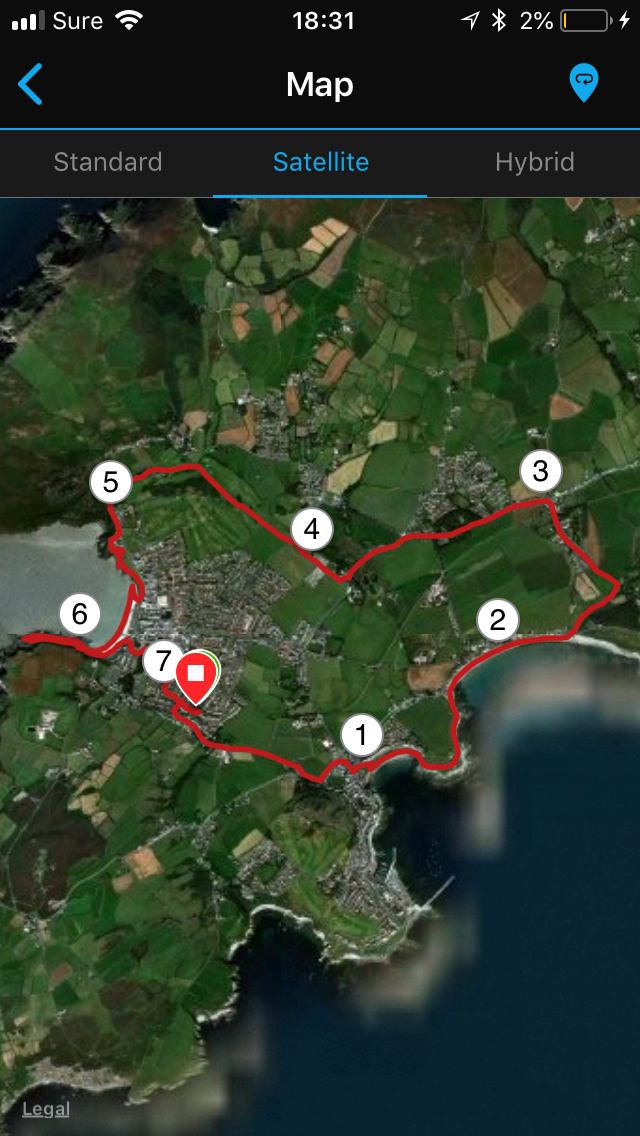
Today, I had hoped to get in a good walk, but of course in addition to normal work  it was RESULTS day for my Psychology students, so I wasn’t able to get out until 4pm and I had calls lined up for the evening with my online students. I wanted a walk that was basically flat where I could walk briskly and get my heart rate up as I hadn’t managed any intensity minutes yet this week. This walk did exactly that and had the added bonus for some of you that it would make an excellent running or jogging route, and you could expand or curtail it in any direction quite easily. You could turn it into a linear walk and get the bus or train back to Port Erin, or stop at the half way point at Croit Y Caley and do the same.

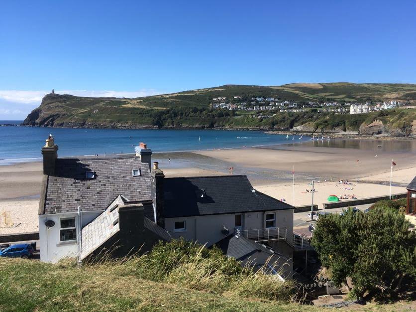
Those of you who follow me on Facebook will know I got absolutely drenched last night on the way home from teaching ballroom dancing. It is only a 5-7 mins walk and I was completely soaked through and there were streams of water on the roads. This afternoon the weather couldn’t be more different and I set out in brilliant sunshine, not a drop of rain in sight. I took the Truggan Road to Port St Mary, then followed the coast up to the Shore Hotel at Gansey, where I turned up to take the road roughly north towards Croit Y Caley.  The first two miles were so lovely. I do like it when the tide is in as it was today. The shoreline looks so perfect without the messy pebbles scattered all over the beach, and today it looked so blue.
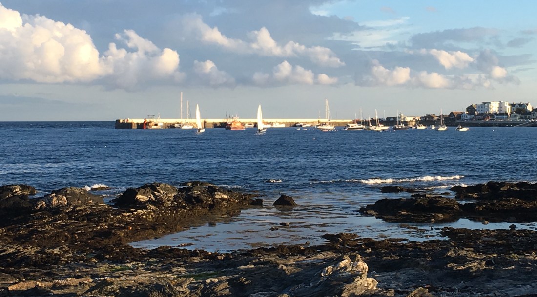
IMG_5355

Photo: Gansey Bay

IMG_9586

Photo: The Mill at Kentraugh

The country lanes to Croit Y Caley are quiet and unspoit but there are no pavements. There are some nice looking traditional houses in this village and they look very cosy. After Croit Y Caley you hit the main back road with all its traffic, but you don’t go far along here, and there is a pavement. At this point you will have walked about 3 miles and you could get the bus back or the train from the Levels.

At the roundabout I turned left, past the tiny but perfectly formed Ballachurry Nature Reserve, and turned right at Kirk Christ, passing by the old cemetery and skirting round the Ponyfields estate in the distance.

IMG_4122

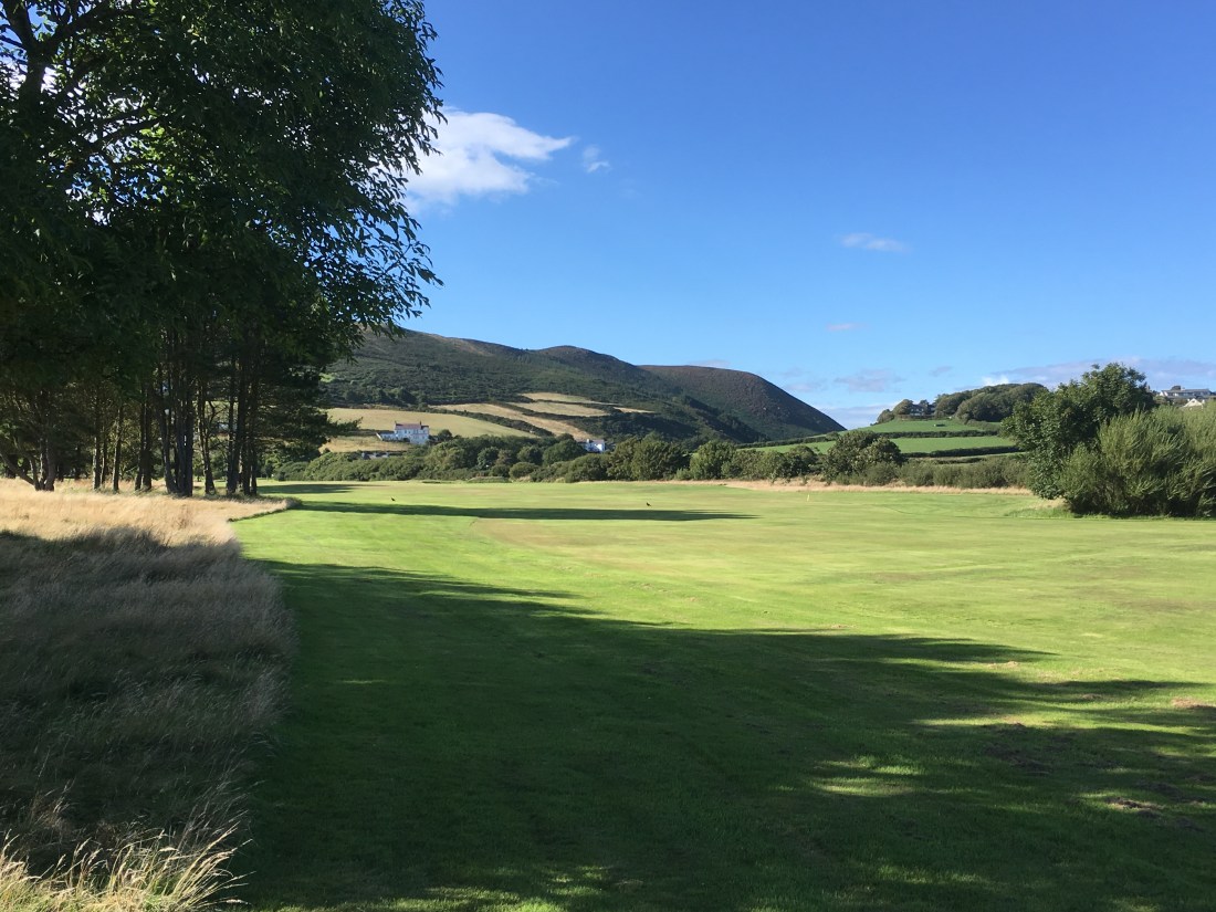
All this still on roads,and again no pavement, but there is virtually no traffic at any time on this road.  On meeting the Ballafesson road, I crossed immediately over to join a path going through the Rowany Golf Course. The view towards Fleshwick is stunning, helped of course by the glorious weather. On exiting the Golf Course, I turned towards Port Erin and followed the coast path (passing by my old flat on the cliff with its wonderful bay views) down onto the beach. I stopped at my favourite place where the waves crash against the rocks before continuing walking along the beach and up onto the far prom and the old breakwater, which was not visible at all today. After that, it was just the standard walk home.

IMG_1554

As you have read, most of this is on pavements or barely used roads, so you take a pushchair or a wheelchair all the way. If you don’t want to go over the Golf course, you can simply take the road back into Port Erin. You can start the walk by parking in Port Erin, taking the Ballafurt Road from behind the beach and then turning on to St Mary’s Road, which becomes Truggan Road.


IMG_5098

Not sure when my next blog will be. Sadly, I have a funeral of a very good friend to attend tomorrow, and the weather forecast isn’t great for the weekend, not that that usually puts me off. We’ll see.

Kirk Michael, Cronk & Orrisdale, 11th August 2018 – 8 miles

This is a walk of contrasts – so different from the coastline of the south and Peel with its hills and cliffs of manx slate, sandstone and limestone. To the north of Peel we encounter miles of sandy beaches and sandy cliffs doing their best to fall into the sea. It is here at Kirk Michael that the remains of the ancient Giant Deer has recently been plucked from the crumbling cliffs and is being examined by the Manx Museum.

IMG_3057.JPG

I parked in Kirk Michael and walked along the main road with a completely different plan to the walk I actually did. Passing by the church on the left with its signpost to the Bishops’ Graves I turned left on a road towards a camp site. This was a wooded road with a stream running down to the sea – or it would have been if we had had any rain in the last two months. It was bone dry today.


When you reach the coast you are filled a sense of peace as the vista opens up into a massive expanse of sea, sand and uninterrupted cliffs. The tide was in, so I walked cautiously along the foreshore for 3-4 miles to the north, accompanied by the sand martins, seagulls, terns, oystercatchers, shags and cormorants who flew on ahead of me every now and again. I also happened to come across a seal that had been washed up onto the shore.

The cliffs are described as precipitous with danger of falling rocks. There was evidence all along of major slippages and I wouldn’t have cared to stop and stare too long there with the wind blowing as it was.


As I reached the far end, the cliffs  fell away into sand dunes where I stopped for lunch and enjoyed the views. There is a car park here for those who might like to do part of this walk.


To the north, I could see Jurby church just a stone’s throw away, but I had walked far enough and the rain clouds were gathering, so I decided to start the return route, this time slightly inland, following country roads and the heritage railway track. These were not disappointing as they afforded wonderful views of the local hills and Snaefell even with its unattractive topping of pylons and ugly buildings. It is hard to spoil any view around here.

As I walked along the Orrisdale road, there were sandy fields to left and right, and I wondered in years to come what other mystical creatures might be unearthed from its bowels. The heritage railway track, which in former times went from Ramsey to Peel was very pleasant. There were loads of butterflies but most fluttered by me before I had time to work what they were. The blues were in evidence everywhere. In fact, blue seemed to be the colour as there were little clumps of harebells on the wayside.

IMG_9742.JPG

All in all, a gorgeous walk. I shall return to the Cronk car park and continue northwards along the beach another time.

I am having a lot of difficulty uploading photos so I can only show you certain ones. I shall have to investigate….

Local Walks round Port Erin & PSM – 8/10th August 2018

Over the last few days, despite best intentions I have only managed local short walks – 2 x 3+ mile walks, and today a 4 mile walk. My aim on short walks is to achieve my 10,000 steps in the nicest possible way – not too difficult when I am surrounded by beautiful countryside. Incidentally 3-4 miles will be between 6,500 and 8,500 steps so not enough on their own  to complete the daily target but well on the way. I won’t bother you with the actual routes for these, but if you want details just contact me.

Wednesday evening I walked with a friend from Port Erin along the main road to Carrikey Bay, round the coast to Chapel Bay in Port St Mary, then back to PSM along roads. A nice way to catch up with friends.

IMG_9320

Thursday, I walked down to Port Erin beach, a round trip of just over 3 miles. We have had few interesting shells lately, but many many jellyfish including moon jellyfish and some spectacular lion’s mane jellyfish. These were a good size whereas the moon jellyfish were mainly just babies washed up on the beach.

Today, I have walked to Port St Mary, along the top edge of the golf course to Perwick Bay. The tide was really far out. I don’t think I have seen so much rock exposed in that region before. I followed the coastline back into PSM on the underway, carried on towards Four Roads and then took the footpath across the fields back to Port Erin. It was a lovely afternoon and this took about 90 mins, so not a great deal of time. I would be quicker if I didn’t call in at the Coop and load myself up with potatoes, meats and veg!!

I doubt if I shall be doing a long walk this weekend and I am on duty at one of the Wildlife Reserves on Sunday, so instead of describing walks, my next blog will consider the costs and benefits of using fitness monitors.

Tuesday 7th August 2018 – Carnanes & Cronk Ny Arrey Laa

Well, it has taken me a few days to get round to blogging about the sensational figure of eight walk across the Carnanes up to Cronk Ny Arrey Laa on Tuesday.

This 7.75 mile /1440 ft walk starts at the picnic spot overlooking Carrikey Bay on the Port Erin to Round Table road. It is just a short walk along the road until you cross over onto the moorland of the Carnanes. There is no climbing involved at this stage as you are starting from high up. Of course, if you want a longer walk with more ascent you could start at Ballafesson, Surby or Fleshwick and take the green route to the starting point.

I followed the lower path around the Carnanes as this is relatively flat and a good stretch to warm up the legs. It joins the green road after about half a mile and then there is a good wide grassy path all the way to the Sloc where the green road meets the main road. With the lack of rain this was easy today, but in winter it can be quite muddy and rutted. Scuttling through a couple of gates, I then began my ascent around Cronk Ny Arrey Laa.

I took the footpath to the north-east that follows high above the road in order to have even more fantastic views on the return route. Even so, this is still beautiful as you have uninterrupted views of the south of the island and can see the variety of landscapes. As you climb gradually along this path South Barrule comes into sight, peaking above the closer hills. At the top  (about 3 miles from the start), we meet the main road where this turns right, and the footpath goes left to take you to the top of Cronk Ny Arrey Laa. This is about another half mile or so of uphill. You can’t miss the top as there is both a trig point and a cairn, ever increasing in size.


This makes the perfect lunch stop though it is likely to be a tad windy.

You can see all the big mountains to the north, including Snaefell, make out the contours of the coastline in all directions, and to the south the magnificent cliffs create wonderful shapes in different lights. It is even possible to see across to Ireland in the west, Scotland in the north, and Anglesey to the south! If you go past the cairn just as far as the path continues (otherwise you will drop into the sea!) you will be rewarded with stunning views and photo opportunities. 


From this point, I headed south – another day I shall continue to Niarbyl, but that’s another story – down the moorland and the well delineated path. I met a lady walking from Port Erin to Peel, a distance of 14 miles and some considerable ascent and descent. I also met the ground at one point as when I placed my foot on some turf it just disappeared. So there was I, sprawled on the ground, looking most unladylike, splattered out like a flat fish:-) Fortunately no injuries and I was soon back on my feet.

I did a slight detour because there is a path to nowhere at the centre point of the figure of eight. This wasn’t desperately exciting, but it is possible to climb some rocks up to the old fort and any spot around there is lovely for a picnic.

Then upwards again over the Carnanes. 

There is a fairly steep climb initially but it doesn’t last long. I just love this set of hills at this time of year, and the closer you get to Fleshwick the more heather and Manx gorse. It was so beautiful, and hardly anyone seems to come up here, at least not while I’m there. I nearly always have it to myself. You can vary the route across these warm hills, and once up there is no more ascent, so if you don’t fancy the full route, the Carnanes makes a great short 4 mile walk on a good day

And what a good day it was!!

Best Foot Forward…..

I don’t know about you, but I feel alive when I am outdoors, and what can be better than spending time walking around the beautiful Isle of Man. There is such a variety of walks, from strolls along the beach, along forgotten railway trails, down the (often steep) wooded glens with secret waterfalls tucked inside, across the windswept moors, or over the switchback hills. I won’t call them mountains as we only have the one over 2,000ft and that is Snaefell. All this in an island 32 miles long and 14 miles wide at best.

The purpose of this blog is to share with you some of the many and varied walks I undertake. I aim for one ‘long’ walk per week, long being a minimum of 6 miles, which isn’t really very long, but it can be up to 10 or 12 miles if I have the time. If I remember to set my Garmin, I record the route which I will post with photos taken en route on my mobile. More often I do shorter daily walks between 3-5 miles. I am fortunate in that I am spoiled for choice of route where I live, so I never get bored.

I usually manage the recommended 10,000 steps minimum per day (5 miles) and of course most hiking involves a degree of ascent, so quite often I add to my intensity minutes for the week. Given this helps the bones, muscles, heart and lungs to stay strong and as a by-product keeps the weight off, it is also a healthy hobby. On a planned longer walk I often aim for a brisk walk for the first hour with odd stops to take in the scenery and then I take the rest in a more relaxed manner.

Walking at any speed is always better than sitting on your bum, but casual and intermittent walking doesn’t really have much of a health benefit, although it is good for the soul. For health benefits you need to feel you have done it, and  exploring your local countryside is a great way to do it!

So, to get started on the next page, I will shortly upload details of my walk on 7th August 2018.